 |
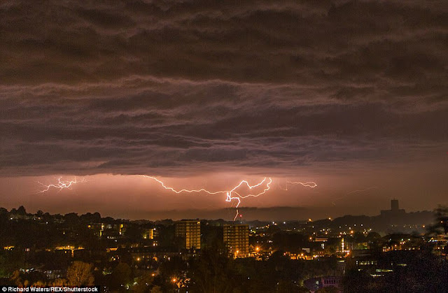
| Lightning turned night into day |
Rescue services were also sent out to pump water out of properties in the south east overnight after heavy downpours caused water levels to rise.
Meanwhile teams in Kent spent two hours overnight removing water from homes in Tunbridge Wells after sixty emergency calls were made in less than an hour including reports of more than 3ft of water in some properties.
Today more warnings are in place for thunder, heavy rain and possible hail across almost the whole of England and Wales apart from the South Coast, with potential for 1.2ins of rain in an hour, or even up to 2ins (50mm) of rain where conditions linger.
Some areas of the UK received more than half a month's worth of rain in just one hour on Tuesday, as flash floods hit parts of Cornwall and Kent.
 |
| Lightning turned night into day |
The giant summer storm brought torrential downpours, thunder and more than 100,000 strikes of lightning during the night.
Amateur photographers across the country were on hand to capture some stunning images of the early morning storm.
Craig Snell, from the Met Office, said: 'The thunderstorms were down to the hot air we have seen move up from Spain in the last 48 hours.
'The humidity at this time of year is the perfect recipe for summer thunderstorms.
'We saw a wide band of thunderstorms move across many southern counties all the way to West Cornwall.
'There were more than 100,000 lightning strikes UK wide overnight but quite a lot of them stayed in the cloud and didn't hit the ground which gave many people an amazing light show that turned night into day.
'We will probably not see another storm like that for the foreseeable future.
 |
| Some areas of the UK received more than half a month's worth of rain in just one hour on Tuesday, as flash floods hit parts of Cornwall and Kent. |
This is more than half the average rainfall expected over the entire month of July, which is usually around 2.3in (57.5mm).
Clean up operations have begun across the worst-hit areas of the country and council leaders have pledged 'money won't be a problem' for extensive repairs.
Coverack in west Cornwall, saw people winched to safety from their homes as floodwaters coursed through narrow lanes and turned roads into rivers.
Other communities remain on standby, with the threat of further heavy downpours and the risk of disruption to power networks from lightning strikes.
 | |
|
A yellow weather warning is in place through the day for large swathes of England and Wales, with the Met Office predicting a month's worth of rain could fall in some places in a matter of hours.
Water had to be pumped out of a number of properties in Tunbridge Wells, Kent, after the fire service received more than 60 calls to the 999 line within an hour.
In Sussex, fire crews received 57 calls about flooding through the night.
Cambridgeshire Police said the adverse weather conditions caused problems with its non-emergency 101 service.
The storms hit Suffolk and Essex around 3am, cutting off the power supply to hundreds of homes.
According to UK Power Networks, electricity is currently out in a host of towns and villages including Framlingham, Martlesham, Hasketon, Halesworth and Blundeston.
According to UK Power Networks, electricity is currently out in a host of towns and villages including Framlingham, Martlesham, Hasketon, Halesworth and Blundeston.
A block of flats was struck by lightning in Winston Close, Felixstowe, around 4.30am, causing a fire, and one man was treated for smoke inhalation.
 |
| Lightning turned night into day across the UK |
Further thunderstorms are due later today but the Met Office believes 'the worst has passed'.
Mr Snell said: 'We may see a few more thunderstorms later in the afternoon and evening but they will be nowhere near as extreme as last night.
'If you don't like thunderstorms, thankfully it appears we've seen the worst of it.'
In Essex, firefighters were tackling a blaze which broke out in the roof of a semi-detached house in The Street, Bradwell, shortly before 4am.
A spokesman for Essex County Fire and Rescue Service said the blaze broke out amid an intense thunder and lightning storm.
People battling to get to work found trains were disrupted between Bishops Stortford and Stansted Airport this morning because a tree has fallen and damaged the overhead electric wires.
 But flash flooding in Cornwall on Tuesday night was not reflected in the amount of rain recorded by the Met Office in the area.
Forecaster Craig Snell said that the most rain water gauges in Cornwall recorded was 0.08in (2mm) an hour at 2pm on Tuesday.
'Their gauges did not record that much at all,' he said.
Despite these figures, flash floods hit the Cornish coastal village of Coverack, where 50 properties were affected and several people had to be rescued from their homes.
'(Flash floods) can be very, very localised,' said the forecaster.
And Mr Snell said local geography affects whether heavy rain turns into flash floods.
'There are a lot of local factors. If it's more hilly, which is what we saw in Cornwall, water moves quicker. The amount of rainfall in Cornwall might not necessarily cause (flash floods) somewhere else.'
There were also reports of storms in Shoreham-by-Sea, with nearby Shoreham Airport measuring rainfall of 0.8in (20mm) an hour at 1am.
Although there is no strict definition of flash flooding, Mr Snell said to qualify there needs to be a large amount of rain falling during a short period of time.
'It needs to be more than 10mm (0.4in) in the hour to start causing some issues on the roads for example,' he said.


0 comments:
Post a Comment